|
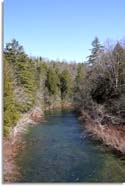
Directions: The Obed Wild and Scenic River is
a narrow crows foot shaped park in rural Morgan and Cumberland
County. All roads leading to and from the parks access points are two
lane "country highways" at best, and 1 1/2 lane curvy, steep, country
roads in places.
From Nashville: take I-40 east to exit 320
(Genesis Rd) at Crossville, TN. Exit, turn left and follow Hwy 298
north to...
Adams Bridge: Adams Bridge is approximately
6.8
miles north of I-40 directly on Hwy 298 (Genesis Rd). (maps
& coordinates)
Barnett Bridge: take Hwy 298 (Genesis Rd)
north to Barnett Bridge Rd., approximately 19.2 miles. Turn left
Barnett Bridge access area 1.5 miles on right. (maps
& coordinates)
Jett Bridge Access: Jett Bridge Access area is
at about 22.5 miles from I-40. Nice paved parking area with about 10
parking spaces, clothes changing station, picnic table and M/F pit
toilets, access directly to Hwy 298 (Genesis Rd). (maps
& coordinates)
From Knoxville to Adams, Barnett, Jett Bridge
Access: take I-40 west to exit 320
(Genesis Rd) at Crossville, TN. Exit, turn right and follow Hwy 298
north to...
Adams Bridge: Adams Bridge is approximately
6.8
miles north of I-40 directly on Hwy 298 (Genesis Rd). (maps
& coordinates)
Barnett Bridge Access Area: take Hwy 298
(Genesis Rd) north to Barnett Bridge Rd., approximately 19.2 miles.
Turn left, Barnett Bridge access area 1.5 miles on right. Gravel
parking area, M/F pit toilets. (maps &
coordinates)
Jett Bridge Access Area: Jett Bridge Access area is
at about 22.5 miles from I-40. Nice paved parking area with about 10
parking spaces, clothes changing station, picnic table and M/F pit
toilets, access directly to Hwy 298 (Genesis Rd). (maps
& coordinates)
|