Black Mountain Trailhead
Latitude: 35° 51.936'N
Longitude: 84° 53.694'W
Elevation:
 The Grassy Cove section of the
Cumberland Trail is a 12.6 mile
section between Black
Mountain and The Grassy Cove section of the
Cumberland Trail is a 12.6 mile
section between Black
Mountain and Camping is permitted only in the established
campsite about .7 of a mile from the trailhead. Camping is free but registration is required
for camping at the Black Mountain campsite. you can
register to camp on-line.
|
| Black Mountain Trailhead - Take
exit exit #329 off of I-40 Crab Orchard 10 miles east of Crossville Tennessee. Go
south for 1.6 miles to Owl Roost Road, turn left. Continue up the
mountain 2.5 miles to a parking area on the right at the base of
large tower.
The trail is located 50 yards south of the parking area near the
covered spring house, a small rock building with a natural feed water
supply. Walk through the parking lot past the orange barriers. Cross
the road following the narrow, paved, cross road for about another 30
yards, you will see a sign.
|
The water at the springhouse is has always seemed to be a good water supply. I have been
going here for 20 years and I don't remember it ever being dry, Of
course it does need to be treated, filtered or boiled.
|
The trail stays along the top of the
mountain for about .4 of a mile then heads down hill through a
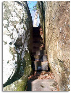
natural stone hallway (pictures above). Make your way through a garden of giant stones
walking at the feet of giant boulders. If your day hiking this
section plan to spend a little time wandering around and on the
boulders, they are incredible.
|