|
Parking: Rainbow Falls Trailhead is located on Roaring Fork Motor Trail
approximately 3.5 miles from Downtown Gatlinburg. Turn at light #8 in downtown Gatlinburg and follow Airport road
Approximately 1 mile to the Great Smoky Mountain National Park. At this point Airport road changes into Cherokee Orchard Road. Continue on Cherokee Orchard Road for About 2.4 miles you will see signs for parking area. The Trail is well marked and starts near the entrance to the parking area.
Elevation: The elevation gain from the Rainbow Falls parking area to Rainbow Falls is about 1,500 feet in 2.7 miles, the elevation gain from the parking area to Mt. LeConte Lodge is almost 4,000 in 6.7 miles.
Rainbow Falls Parking Area - 0.0
The trail follows LeConte Creek for about the first mile or so with a mild elevation gain. The trail then winds away from the creek out to an exposed ridge where nice views can be seen in the winter.
Log Bridge 1.5 - The first of 3 log foot bridges that cross LeConte Creek. A short series of switch backs follows.
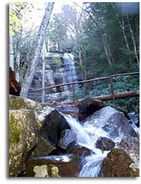
Log Bridge 2.5 - While crossing this bridge Rainbow falls can be seen up to your right.
Log Bridge 2.6 -
Rainbow Falls - 2.7
|