 Section Rating: Strenuous Section Rating: Strenuous
Distance: 71 miles
Map of Appalachian Trail (1Mb)
Smoky Mountain Map -
Trails
A seventy mile section
of the
Appalachian Trail crosses through the Great Smoky Mountains
National Park, the trail wonders in and out of Tennessee and North
Carolina.
Since the Appalachian Trail is fairly remote to most
sections of the park you actually won't see a lot of people except
for the areas around
Clingman's Dome and the section between Newfound
Gap and Charlies Bunion, a popular day hike destination.
If you have any questions about this section of the AT please post them in our
hiking discussion
forum. I have hiked many the these trail miles several times and can
probably help. |
| |
Most
people use take 7 days to hike the Smoky section of the AT. If you
don't have that much time this hike can be easily shortened by using
Newfound Gap or
Clingman's Dome as a mid point. Either of these sections of the
AT can be done in 3 or 4 days depending on whether you hike the
section between Clingman's and Newfound Gap. Of course since these
are all one-way trips you will have to arrange for some sort of
transportation at the end of your hike.
|
Most people sleep in the shelters that are
spread out along the Appalachian Trail. One good thing about that is
it eliminates the need for a tent. Reservations are required for the
Smoky Mountain shelters and
can be made by calling (865) 436-1231. This trip starts at
Fontana Dam in the Southwest corner of the park. I will add more
descriptions and photos as time allows. There is plenty of parking at
the Fontana Dam. To get to the trail walk across the dam and then
follow the signs. The following is a list of distances, in miles, elevation, in feet, and
brief trail description of each segment. I have included the
coordinates for some known points. |
|
|
Fontana Dam - 0.0
Steep hiking!! Be sure to stop and check out the
view from the fire tower which is down a short side trail on the East side of the AT. Fantastic view of
Fontana Lake and the surrounding Valley. |
|
Shuckstack - 4.0 |
BirchSpring Gap Shelter - 5.2
Latitude:
Longitude:
Elevation: 3,680'
shelter is on the West side of AT, small spring close to Shelter
|
|
|
Doe Knob - 7.5 |
|
Ekaneetlee Gap - 8.9 |
Mollies Ridge Shelter - 9.8
Latitude: 35° 32.746'N
Longitude: 83° 47.616'W
Elevation: 4,570'
|
|
|
Devils Tater Patch - 10.1 |
|
Little Abrams Gap - 11.5 |
Russell Field Shelter - 12.4 Latitude: 35° 33.704'N
Longitude: 83° 45.996'W
Elevation: 4,360' |
|
Eagle Creek Trail to Spence Field Shelter(4,900'); Bote Mountain Trail - 14.9
|
Spence Field Shelter - Latitude: 35° 33.707'N
Longitude: 83° 43.963'W
Elevation: 4,915' |
|
Rocky Top - 16.1
a great place to take a break or have lunch. Great views of valleys below.
|
Thunderhead, east peak - 16.7
After reaching Thunderhead peak there is
a pretty steep downhill section through mature hardwoods. |
|
Beechnut Gap - 17.0 |
|
Mineral Gap - 17.7 |
|
Sugar Tree Gap - 20.1 |
Derrick Knob Shelter - 21.2
Latitude: 35° 33.974'N
Longitude: 83° 38.514'W
Elevation: 4,890' |
|
|
Sam's Gap - 21.4 |
|
Buckeye Gap - 24.0 |
Siler's Bald Shelter - 26.7
Latitude: 35° 33.851'N
Longitude: 83° 34.1'W
Elevation: 5,460' |
|
|
The next 34 miles of trail of the trail are the highest of the entire
Appalachian Trail staying at an altitudes higher than 5,000 feet. |
|
Siler's Bald 26.9 |
Double Spring Gap Shelter - 28.4
Latitude: 35° 33.91'N
Longitude: 83° 32.571'W
Elevation: 5,505' |
|
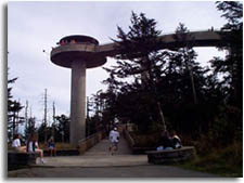
Clingman's Dome - 31.3
Latitude: N 35°33'46"
Longitude: W 83°29'56"
Elevation: 6,643'
Highest elevation in the Great Smoky Mountains National Park, also the highest elevation on the Appalachian trail
and 2nd highest mountain east of the Mississippi river. There is an observation
tower open to the public at the top of the mountain.
|
Clingman's Dome |
Clingman's Dome also has a
parking lot .6 miles from the peak, so emergency access is available as well as
a way to leave the trail if needed. There is also a rest room so this can be a
great place to get that much needed real bathroom after the 3 or 4 day trip to
this point. Another interesting thing about Clingman's Dome is that this is the
western terminus to the Mountain to Sea trail.
|
|
Mt. Love - 32.5 |
Mt. Collins Shelter - 34.7
Latitude: 35° 35.623'N
Longitude: 83° 28.284'W
Elevation: 5,870'
.5 miles off of AT.
|
|
|
Indian Gap - 37.5
|
Newfound Gap, US 441 - 39.2
Latitude:
Longitude:
Elevation: 5,046'
this is the only place the AT crosses the road within the park. It is also the easiest place to have extra supplies or to cut the trip in half.
|
| Sweat Heifer Creek Trail
1.7 - Trail intersects on the right, this is Sweat Heifer Creek
Trail. Shortly after this intersection you start a short but steep section
of trail. |
| Boulevard Trail 2.7 -
Boulevard Trail comes in from the left. This is a popular trail that leads
to Mt LeConte. |
Icewater Spring Shelter - 42.2
Latitude: 35° 37.78'N
Longitude: 83° 23.183'W
Elevation: 5,920'
because it's so close to New Found Gap this is one of the most crowded shelters in the park.
|
|
Charlies Bunion - 43.1
offers a great panoramic view from a large
rock outcrop. Great lunch/ break area. Nice place for a day
hike from Newfound Gap parking area.
Longitude: 35° 38.357'N
Latitude: 83° 22.307'W |
The Sawteeth - 45.0
Great views of both Tennessee and North Carolina
with occasional steep drops next to trails edge (watch kids).
|
|
Bradley's View - 48.3 |
Pecks Corner Shelter - 49.6
Latitude: 35° 39.044'N
Longitude: 83° 18.515'W
Elevation: 5,280'
.5 miles from AT.
|
|
|
Mt. Sequoyah - 52.3 |
|
Mt. Chapman - 53.8 |
Tri-corner Knob Shelter - 54.8
Latitude: 35° 41.619'N
Longitude: 83° 15.398'W
Elevation: 5,920' |
|
|
Guyot Spring - 56.6 |
|
Mt. Guyot Side Trail - 56.7 |
|
Snake Den Ridge Trail - 58.6 |
|
Cosby Knob - 62.0 |
Cosby Knob Shelter - 62.5
Latitude: 35° 43.624'N
Longitude: 83° 10.931'W
Elevation: 4,700' |
|
Mt. Cammerer Side Trail - 65.3
Latitude: 35° 43.624'N
Longitude: 83° 10.931'W
Elevation: 4,928
Additional LinkThis is a great .5 mile side trip out to a unique Yosemite
style octagonal rock and glass fire tower. From the top of this mountain down to
the park boundary is steep down hill. You |
|
will go from about 5,000' down to about 2,000'.
|
|
Spring - 65.8 |
|
Spring - 67.4 |
Davenport Gap Shelter - 69.6
Latitude: 35° 45.803'N
Longitude: 83° 9.671'W
Elevation:2,600' |
|
|
Davenport Gap, Tennessee 32, NC 284; eastern boundary, Great Smokey Mountains National Park - 70.5
If you have to park at this end of the park be sure to park at the ranger station.
In the past there has been problems with vehicles getting broken into in this area.
|
|
Related Links
& Resources:
●
Great Smoky Mountains National Park
●
Appalachian Trail
National Park
●
Backpacking
●
Cherokee National Forest
●
Pisgah National Forest
●
●
● |
|
|


