|
Distance: 2.6 miles round trip
Difficulty: Easy, paved
Longitude: 35° 40.434'N
Latitude: 83° 26.976'W
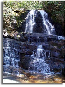 Laurel Falls is located in the
Great Smoky Mountains National Park. The 1.3 mile trail to the falls is paved and
suitable for strollers and walkers of most ages and abilities. The trail
was originally built in 1935 by the Civilian Conservation Corp and was
later paved because of excessive wear do to heavy foot traffic. Laurel Falls is located in the
Great Smoky Mountains National Park. The 1.3 mile trail to the falls is paved and
suitable for strollers and walkers of most ages and abilities. The trail
was originally built in 1935 by the Civilian Conservation Corp and was
later paved because of excessive wear do to heavy foot traffic.
|
| Trailhead: The parking
area for the falls is located 3.6 miles west of the Sugarlands visitor center, on Little River rd (scenic RT
73). There is parking on both sides of the road, but the parking lots are
frequently full. The trailhead to Laurel Falls is located on the north
side of Little River Road.
|
Laurel Falls - 1.3
Longitude: 35° 40.434'N
Latitude: 83° 26.976'W
Laurel Falls cascades from the right hand side of the trail, crosses it,
the goes off the left hand side of the trail
Beyond the falls the trail
continues to climb the mountain. With most people stopping at the falls the
pavement ends and the trail becomes rough and rocky and virtually deserted
compared to the lower section. |
| Great Smoky Mountain Maps:
|
| Related Links & Resources:
|


