Center
Hill Lake
 Center
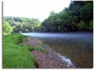
Hill Lake near Smithville and Cookeville in Middle Tennessee
is a 64 mile long lake with over 400 miles of
shoreline. Center Hill is a great vacation spot for
house boating, skiing, hiking, swimming, picnic,
fishing and much more. Center
Hill Lake near Smithville and Cookeville in Middle Tennessee
is a 64 mile long lake with over 400 miles of
shoreline. Center Hill is a great vacation spot for
house boating, skiing, hiking, swimming, picnic,
fishing and much more.
<Center
Hill Lake> |
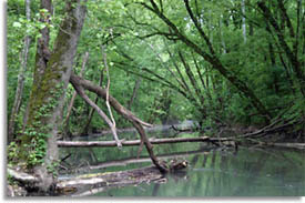
Caney Fork River
 The
Calfkiller River emties into the
Caney Fork River in Middle Tennessee. The Caney Fork then forms
Center Hill Lake. The
Calfkiller River emties into the
Caney Fork River in Middle Tennessee. The Caney Fork then forms
Center Hill Lake.
<Caney
Fork River> |


 Calfkiller
River
is located in Putnam and White Counties in middle Tennessee.
Originating
south of
the town of Monterey, the Calfkiller river flows south for about 20
miles and through downtown Sparta, Tennessee before
emptying into the
Calfkiller
River
is located in Putnam and White Counties in middle Tennessee.
Originating
south of
the town of Monterey, the Calfkiller river flows south for about 20
miles and through downtown Sparta, Tennessee before
emptying into the