|
|
This article will cover some basic information about trout fishing on the
Caney Fork River in middle Tennessee. I will not
specifically cover fly fishing techniques, but I will give some tips on fly's. In addition much of this information can also be used on other area rivers. However, since the regulations vary from area to area, and year to year, you need be certain you are familiar with each
specific areas regulations before going fishing.
|
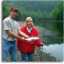
Brian & Missy With her first
Caney Fork River Rainbow Trout |
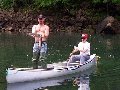
The Caney Fork can be fished from the bank, by wading, or you can
canoe the Caney Fork
fishing along the way. Because of frequent shallow areas float tubes generally
do not work to well.
The River
The portion of the Caney Fork that is stocked with trout
begins at the Center Hill Dam and runs downstream to where the
Caney Fork merges with the Cumberland River. The Tennessee Wildlife Resources
Agency (TWRA) stocks over 100,000 Rainbow and Brown trout into the Caney Fork
River each year. Center Hill Dam is
located 65 miles East of Nashville, TN, and just a few miles
South of I-40 exit #268.
I prefer to fish for trout on the Caney Fork when they are not
generating at the Center Hill Dam. You can check the generation
schedule for Center Hill and other Tennessee dams at
TVA Web Site or by calling 1-800-238-2264, Center Hill Lake is #37.
The Caney Fork River is about 20-30 yards wide in most areas with
a slow but noticeable current. The riverbed is made up primarily golf
ball size gravel covered in a dark green moss, and is very good for
wading. In addition most access areas along the river offer fishing
from the shore as well as wading.
|
The Gear
I like to use ultra light rod and reel. My fishing rod is a 4'6"
spinning rod--1/32-1/8 oz lure--2 to 6 lb test. It is a name brand,
but that's not important. My ultra light reel holds 4-8 lb test, I
use a clear, 4 lb test, Trilene line.
The Methods
There are basically 3 methods used to catch trout on the Caney Fork,
and most rivers for that matter. Fly fishing, bottom (or bait)
fishing, and fishing with lures.
Fishing with lures ~ requires a lot more activity on your part, but can
be action packed. Some of the lures I like to use are Panther
martins, Rooster Tails, small Rapalas,
Bottom Fishing ~ Baits include corn, Salmon Eggs (red, pink, or orange),
Power Bait, mini marshmallows.
|
Public Access
The entire length of the Caney Fork river is public. However, most
of the land along the river is private. Please respect the landowner
and do not cross land that you do not have permission to be on. There
really is no need to cross private land anyways. There are plenty of
places with access that do not require it. I will list several access
areas starting at the dam and working our way down stream by road.
 Center Hill Dam is a great place to fish. There is lots of room
to park on either side of the dam, and plenty of room to fish as well.
From I-40 exit #268 turn South and go 3.7 miles to the stop sign at
Big Rock Market, turn right at the stop sign and go .3 of a mile to
and watch for the 'Resource Managers Office' sign and turn right. A
short .2 mile drive will take you to the parking lot, or if you intend
to canoe or launch a boat, drive another .1 mile beyond the parking
lot to river. From the parking area you can venture from the dam down
river as far as you are willing to walk. Center Hill Dam is a great place to fish. There is lots of room
to park on either side of the dam, and plenty of room to fish as well.
From I-40 exit #268 turn South and go 3.7 miles to the stop sign at
Big Rock Market, turn right at the stop sign and go .3 of a mile to
and watch for the 'Resource Managers Office' sign and turn right. A
short .2 mile drive will take you to the parking lot, or if you intend
to canoe or launch a boat, drive another .1 mile beyond the parking
lot to river. From the parking area you can venture from the dam down
river as far as you are willing to walk.
To get to the West side of the dam (Long Branch recreation area) again
turn right at the stop sign near big Rock market and continue to drive
until you cross the dam, you can't miss it. After crossing the dam turn
right at the first road, Hwy 141. From here you can see the parking
area near the power station at the base of the dam. Again from here you
can venture down river as far as your willing to walk. If you do intend
to walk a ways down stream the East side of the Dam may actually
be a little better.
There is a campground located at the base of the dam on the West side of the
river, campground reservations may be made by calling
1-877-444-6777.
|
Hwy 141 has several pull-offs that allow easy access to the river,
but no ramps. Again the easiest way to get there is to exit I-40 at exit#268
go South until you come to the stop sign at Big Rock Market (3.7 miles) and
turn right. After you cross Center Hill Dam Turn right at the first road,
this is Hwy 141. The best pull-off area is about 2 miles north of the dam
on the right hand side of the road, the river is just yards from the Highway.
Happy Hollow Access Area - provides a gravel parking, easy access
to the river and a gravel ramp for either launching a boat during generation
or easy access for canoes to put in or take out. Happy Hollow access area
is located on the Putnam Deklab county line just 1.3 miles south of I-40 exit
#268 and is visible on the West side of the road, there is small brown Happy
Hollow Access sign at the parking area. When generation starts at the dam the
rising water takes approximately one hour to reach Happy Hollow.
|
Rest Area at I-40 - This is a good fishing area to access by foot, but
for canoe access use Happy Hollow Access Area. It's only .25 mile up stream, and
you can drive right to your boat. If you use the rest area you have to carry
your things .2 of a mile and cross an exit ramp. For foot traffic the rest area
provides extremely easy access, lots of paved parking and access to a mile or
more of fishable shoreline. To get there simply exit I-40 at the rest area just
west of exit #268. The rest area has 2 parking lots, the lower lot (where the
East bound traffic enters first) is the best place to park for easy access.
Betty's Island Access Area - has a gravel parking area and good
river access. There is no boat ramp but there is easy access to put in or
take out a canoe. To get there Take I-40 exit#268 and go North 1.9 miles to
St. Mary's Road and turn left. Take St. Mary's Rd 4.1 miles and you will see
a small brown Betty's Island sign on the left at the entrance to the parking
area. When generation starts at the dam the rising water takes approximately 2.5
hours to reach Betty's Island.
Kirby Rd. Road side parking and good river access. There is no boat
ramp but there is access to put in or take out a canoe. To get there Take I-40
exit#268 and go North 1.9 miles to St. Mary's Road and turn left. Take St.
Mary's Rd (aprox)6 miles to Kirby Rd and turn left (last time I was there,
there was no road sign). You can't miss the pull-offs on
the left. This area is about 1.5 miles past the Betty's Island area.
Stonewall Bridge has foot access but no ramp. The bridge is located
where Hwy 264 (Stonewall Hwy) crosses the Caney Fork River. To get there Take I-40
exit#268 and go North 1.9 miles to St. Mary's Road and turn left. Take St.
Mary's Rd 10.4 miles to Stonewall Hwy and turn left, the bridge is just 1/2 mile
away you cant miss it.
|
| Discuss
fishing techniques, ask questions and share tips in our
Freshwater Fishing Forum or Fly Fishing in our
Fly Fishing Forum. |
| |
| Tennessee
Wildlife Resources Agency's
Management Plan for Center Hill tailwater Trout Fishery (PDF). |
| |
|
|
|


